
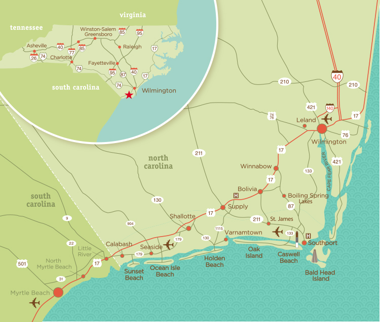
The beautiful barrier-island beaches of North Carolina stretch an impressive 300 miles, with each beach offering something special to visitors. New visitors will find everything from Brunswick Islands’ subtropical climate to the Outer Banks’ majestic lighthouses.
The North Carolina Department of Environmental Quality has created an interactive beach map that makes it easy to explore this stunning coastline. Travelers can spot famous spots like Wrightsville Beach, Nags Head, and Cape Hatteras on the coastal map. The Crystal Coast stands out with its 85-mile shoreline and amazing wreck diving spots, while the Brunswick Islands boast more than three dozen requested golf courses. A detailed beach map helps visitors find charming coastal towns like Southport, known for its waterfront parks and antique shops.
Brunswick Islands: Family-Friendly and Flavorful
The Brunswick Islands stretch along North Carolina’s southernmost shoreline. These barrier islands offer an exceptional coastal experience you won’t find anywhere else. With more than 45 miles of pristine sandy beaches, they create perfect spots for families across generations to enjoy nature’s wonders and local charm.
Sunrise and sunset beach views
Something remarkable happens at the Brunswick Islands that sets them apart from other coastal spots. Their east-west orientation and south-facing beaches let visitors watch both sunrise and sunset over the Atlantic Ocean from late fall through early spring. Weather.com named this rare sight one of “10 Incredible Phenomena You Have to See in Fall”. Beach lovers can stay in their chairs all day and catch both shows!
The morning light paints the sky in brilliant oranges, pinks, and purples as the sun rises over the shore. These beaches stay peaceful and uncrowded, especially at dawn. One visitor described it best: “the morning beach is calm and quiet… not a soul on the beach, and the only footprints were my own”.
The sunsets here are just as magical. Golden light bathes the marsh whether you’re watching from your oceanfront room or enjoying dinner by the water. Some visitors take sunset kayak trips through quiet marshlands, while others join evening cruises to spot dolphins and wildlife.
Calabash-style seafood and local dining
Calabash stands proud as the “Seafood Capital of the World”. This historic fishing village made its cooking style famous in the 1930s and ’40s. The signature technique uses light breading and quick frying to keep seafood’s natural flavors fresh.
The story began with fishermen bringing their catch to Calabash docks. Locals would set up cast-iron kettles right there to fry the seafood. Today’s family-owned restaurants keep this tradition alive, serving generous portions of Calabash-style shrimp, oysters, crab, grouper, and flounder.
These local spots serve up the best seafood experiences:
- Waterfront Seafood Shack serves fresh catches that travel “less than 50 feet from boat to plate”
- Jinks Creek Waterfront Grille pairs marsh sunset views with specialties like their “Jewels of the Sea” – a mix of sautéed shrimp, scallops, and lump crab
- Provision Company at Holden Beach sits by the Intracoastal Waterway and makes a famous grilled shrimp burger
Top beaches: Sunset Beach, Ocean Isle, Holden Beach
The Brunswick Islands feature three exceptional beaches that stand out from the rest.
Sunset Beach, the southernmost spot, earned recognition on National Geographic’s list of 21 Best Beaches in the World. This three-mile stretch preserves untouched sand dunes and provides a home for coastal wildlife, including endangered loggerhead sea turtles. Visitors love walking to Bird Island’s Kindred Spirit Mailbox to share their thoughts in notebooks.
Ocean Isle Beach earned its nickname as the “Gem of the Brunswick Islands”. Palm trees line its streets, creating a relaxed atmosphere that families return to generation after generation. A modern bridge connects this family paradise to the mainland across marsh savannas, with beach paths every 500 feet.
Holden Beach stretches for 9 beautiful miles. National Geographic Traveler named it one of the “Top 10 Family Beaches in the US”. This charming small town backs up to the Intracoastal Waterway, making it perfect for boat rides, paddleboarding, or cycling. Families love its quiet shores and gentle waves.
The Brunswick Islands blend wide beaches, family traditions, and fresh seafood into an authentic coastal experience that keeps visitors coming back year after year.
Crystal Coast: Adventure and History Combined
Looking at any map of north carolina beaches, you’ll find the Crystal Coast as you head north. This 85-mile stretch is where maritime history and outdoor adventures meet. The region has unique experiences you won’t see anywhere else on your north carolina coast map, from historic lighthouses to underwater treasures.
Cape Lookout National Seashore
Cape Lookout National Seashore stands out on any beaches in north carolina map. It runs for 56 miles of untouched beach sand that’s only available by boat. This coastal wilderness shows nature at its wildest and lets visitors enjoy everything from stargazing to wildlife watching.
The seashore’s centerpiece is Cape Lookout Lighthouse, known locally as “the Diamond Lady.” This 163-foot beacon has guided sailors since the mid-1800s and features a distinctive black-and-white diamond pattern. The lighthouse is getting renovated until 2025, but it remains perfect for photographers, especially at night when its beam cuts through this International Dark Sky Park.
Your map of beaches in north carolina will show that Cape Lookout has something for everyone. You can take UTV rides on sand roads or watch birds in peace. The seashore also gives you the East Coast’s best stargazing spots since it’s the only dark sky park on the Eastern Seaboard.
Scuba diving and water sports
The Crystal Coast stands out on any map north carolina beaches for people who love diving. It’s one of just two places in North America where the warm Gulf Stream touches the coast, creating what divers call a “wreck diver’s dream”. The waters are crystal clear with visibility often reaching beyond 100 feet and temperatures around 80°F.
This region’s most fascinating feature on the map of north carolina coast is the “Graveyard of the Atlantic,” where over 2,000 ships have sunk through the years. Some notable wrecks include:
- The U-352, a 218-foot German submarine from World War II lying 110 feet below
- The Aeolus, a 409-foot former Navy attack cargo ship sunk in 1988 as part of North Carolina’s artificial reef program
- The Papoose, a 412-foot tanker torpedoed in 1942 that lies upside down at 125 feet
The map of coastal north carolina shows great spots for kayaking and paddleboarding in different waters. Beginners will love the calmer conditions in the sounds between the coast and barrier islands.
Wild Spanish Mustangs of Shackleford Banks
Shackleford Banks makes any beaches in north carolina map special with its wild horses. This southernmost barrier island in Cape Lookout National Seashore is home to more than 110 wild horses. It’s one of the few places left in the eastern United States where you can see wild horses roaming free.
These horses have a special heritage proven by genetic testing. They carry a rare blood variant called Q-ac that comes from Spanish horses of 400 years ago. Scientists have found this genetic marker only in Spanish horses’ descendants, and it can be lost easily through genetic drift.
Your north carolina beaches map will lead you to these magnificent animals, but keep in mind they’re truly wild. Federal law says you can’t feed, touch, or bother the horses, with fines up to $5,000. Stay at least 50 feet away—about a bus length—to watch them safely. The horses live in about 25 harems, each led by a strong “alpha” stallion who takes his group to water and the best grass.
These three Crystal Coast highlights give first-time visitors a perfect mix of adventure and history as they check out the best beaches in north carolina.
Topsail Area: A Quiet Escape
A 26-mile sanctuary called Topsail Island sits quietly on any detailed north carolina beaches map. This barrier island between Jacksonville and Wilmington has three charming towns that give visitors a relaxed coastal experience. Beach lovers flock here to enjoy uncrowded shores and local charm.
Topsail Beach, Surf City, North Topsail
Each town on Topsail Island has its own special feel. The southern end’s Topsail Beach gives off a “retro, relaxed” vibe with its small locally-owned shops. The beloved Topsail Beach Skating Rink has been running since 1964. TripAdvisor named it the “Best Little Beach Town in the USA”. The pristine beaches make shell hunting and quiet walks a joy.
Surf City sits at the island’s heart as its business hub. The 937-foot Surf City Ocean Pier lets visitors grab ice cream while they fish or take a stroll. Though it’s the busiest area, it feels nowhere near as crowded as other spots you’ll see on a north carolina coast map.
North Topsail Beach anchors the northern tip with some of the most peaceful beaches you’ll see on any map of north carolina beaches. The locals say it’s the best place to look for shark teeth. The beaches here have water on three sides and welcome dogs. This spot stays the least busy part of Topsail Island.
Sea turtle rescue and conservation
The Karen Beasley Sea Turtle Rescue and Rehabilitation Center in Surf City stands out on any beaches in north carolina map. This center saves sick and injured sea turtles and teaches visitors about protecting these creatures.
Loggerhead turtles have made Topsail Island one of their northernmost nesting spots in the world. Female loggerheads come to shore 3-5 times during nesting season from mid-May through August. They lay about 120 eggs each time. The hatchlings break free together after about 60 days and rush to the ocean.
The biggest problem these turtles face is survival. All but one of these 1,000 hatchlings die in their first year, and only one in 10,000 makes it to adulthood.
Fishing, boating, and relaxed vibes
Topsail Island gives fishing fans plenty to get excited about. Three fishing piers dot the island, and charter boats take you inshore, nearshore, or offshore. Local boat captains help you catch flounder and red drum close to shore, or king mackerel, Spanish mackerel, and sharks further out.
Boats are part of Topsail’s soul. You can take pontoon rides through the scenic Intracoast Waterway or watch the sunset while cruising past waterfront homes. Tuck’s Water Shuttle runs trips to Lea-Hutaff Island, a wild 5,000-acre barrier island that serves as an animal sanctuary.
Topsail stands out on any map of north carolina beaches because of its peace and quiet. Visitors and locals call it a “hidden treasure” thanks to its calm beaches and open spaces. First-time north carolina beach explorers will find their perfect quiet getaway here.
Outer Banks & Currituck: Iconic and Untamed
The Outer Banks stands as a remarkable strip on any North Carolina beach map, where raw nature meets rich history. This narrow string of barrier islands has left an incredible mark on America’s story that few coastal spots can match.
Cape Hatteras and the Wright Brothers
Kill Devil Hills holds the Wright Brothers National Memorial, marking humanity’s first powered flight success. Yes, it is here that Wilbur and Orville Wright changed our world forever on December 17, 1903. Visitors can walk the actual flight paths with small monuments showing where takeoffs and landings happened. The memorial shows off reproductions of the brothers’ 1903 camp buildings, a replica of their famous flyer, and a 60-foot granite monument sits proudly atop 90-foot Kill Devil Hill.
Cape Hatteras National Seashore stretches more than 70 miles and has over 30,000 acres as America’s first national seashore. This protected coastline features pristine beaches where shipwrecks near the dangerous Diamond Shoals earned its nickname “Graveyard of the Atlantic”.
Wild horses and remote beaches
North Carolina’s beach magic comes alive when you spot Corolla’s wild Spanish Mustangs roaming free along the untamed shore. These magnificent horses come from Spanish explorers’ steeds of the 1500s and remain the world’s only wild Spanish Mustang herd.
The best chance to see these living treasures comes at the 4×4 beaches where Highway 12’s pavement ends in Corolla. Safety rules say you must stay 50 feet away from the horses. Their strict diet means even small human contact could kill them.
Lighthouses and historic landmarks
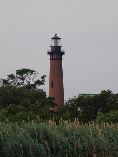
First-time visitors looking at a North Carolina coast map will spot the area’s famous lighthouses. Cape Hatteras Lighthouse shows off its black-and-white spiral design as America’s tallest brick lighthouse at 198 feet. Bodie Island Lighthouse features bold horizontal black-and-white stripes, while Currituck Beach Lighthouse keeps its natural brick look on purpose.
These watchful towers have guided sailors through the dangerous “Graveyard of the Atlantic” waters for centuries. They offer both historical value and amazing views for those ready to climb their steps.
Wilmington Area: Where City Meets Sea
Wilmington anchors the southeastern corner of any North Carolina beaches map, uniquely blending urban sophistication with easy beach access. This historic port city lets visitors experience rich culture and coastal adventures just minutes apart.
Wrightsville, Carolina, and Kure Beaches
Each nearby beach has its own unique personality. Wrightsville Beach stands out on any North Carolina coast map as the state’s surfing birthplace, with crystal blue waters that attract watersports enthusiasts. Savvy surfers catch less crowded waves at spots like Shell Island Resort, Beach Access #4, and Carolina Yacht Club.
Carolina Beach brings relaxed good times with its vintage seaside boardwalk – perfect for families who love a carnival atmosphere. Kure Beach offers a more natural escape and proudly features the East Coast’s oldest fishing pier. These three destinations give travelers everything from upscale beach boutiques to family attractions when they look at a map of beaches in North Carolina.
Historic River District and Battleship NC
Wilmington’s 2-mile Riverwalk, named one of USA TODAY’s 10Best Readers’ Choice Best Riverwalks, connects you to boutiques, al fresco dining, and vibrant nightlife. The Battleship NORTH CAROLINA stands as the crown jewel on any beaches in North Carolina map. This restored National Historic Landmark earned 15 battle stars while participating in every major Pacific naval offensive during World War II.
North Carolina’s schoolchildren saved the battleship from the scrapyard in 1961 by donating their dimes. The memorial now attracts nearly 250,000 visitors each year and runs interactive programs throughout all seasons.
Surfing, gardens, and film locations
Wilmington’s reputation as “Hollywood East” makes it essential on the map of North Carolina beaches. The area has hosted over 400 film and TV productions, including “One Tree Hill,” “Dawson’s Creek,” and “Iron Man 3”.
Nature lovers should visit Airlie Gardens, a 67-acre public space filled with thousands of azaleas, magnolias, and camellias. The gardens become magical between Thanksgiving and Christmas during “Enchanted Airlie,” when themed displays and lights create a holiday wonderland.
The North Carolina coastline gives every type of traveler a unique beach experience. Each region shows its own character and attractions, from the subtropical charm of Brunswick Islands to the wild, untamed beauty of the Outer Banks. Without doubt, the complete North Carolina beaches map will engage first-time visitors with its diverse offerings.
Brunswick Islands stands out because visitors can watch both sunrise and sunset over the Atlantic Ocean. The area also features world-famous Calabash seafood. The Crystal Coast draws adventure seekers with shipwreck diving and Shackleford Banks’ majestic wild horses. Many travelers find their perfect quiet escape at Topsail Island. The Outer Banks becomes a must-visit destination with its historic lighthouses and wild mustangs.
The Wilmington area naturally blends urban sophistication with beach accessibility. This combination of historic sites, film locations, and three distinct beaches creates something special along the North Carolina coast.
North Carolina beaches deliver unforgettable experiences for everyone. Visitors might want family-friendly shores, underwater adventures, serene escapes, or historic exploration. The state’s 300 miles of shoreline offers beautiful coastlines, rich cultural heritage, remarkable wildlife, and culinary delights. These features make it a premier beach destination. Your coastal memories will last a lifetime, so pack your swimsuit, bring your appetite for Calabash shrimp, and get ready for an amazing time.
Here are some FAQs about North Carolina beaches map:
What is the prettiest beach in North Carolina?
Emerald Isle is often considered the prettiest beach in North Carolina with its sparkling turquoise waters and pristine shoreline. For those exploring a north carolina beaches map, you’ll find this gem along the Crystal Coast known for its natural beauty. The beaches in north carolina map shows this area boasts some of the most picturesque coastal landscapes in the state.
What is the nicest beach town in North Carolina?
Beaufort consistently ranks as the nicest beach town in North Carolina with its charming historic district and waterfront views. When checking a map of north carolina beaches, you’ll notice this town offers easy access to both the Atlantic Ocean and inland waterways. The map north carolina beaches reveals Beaufort’s ideal location near popular spots like Cape Lookout National Seashore.
What beach has the clearest water in North Carolina?
Shackleford Banks is renowned for having the clearest water in North Carolina, with visibility that rivals tropical destinations. A map of beaches in north carolina will show this undeveloped barrier island located near Beaufort. The beaches in north carolina map highlights how its remote location helps maintain exceptionally clean, clear waters perfect for shelling and wildlife viewing.
Does North Carolina have beaches and mountains?
Yes, North Carolina uniquely offers both beautiful beaches and majestic mountains within its borders. A north carolina beaches map shows the extensive coastline while the western region features the Appalachian Mountains. The map of north carolina beaches and state geography reveals you can surf in the morning and hike mountain trails by afternoon.
Which NC beach is least crowded?
Bear Island at Hammocks Beach State Park is typically the least crowded beach in North Carolina. When examining a map north carolina beaches, you’ll notice this secluded spot requires a ferry ride to access. The map of beaches in north carolina indicates this hidden gem offers peaceful shores away from busy tourist areas.
Are North Carolina beaches warm?
North Carolina beaches offer comfortably warm water temperatures from late spring through early fall. The beaches in north carolina map shows ocean temperatures peak in July and August, ideal for swimming. A map of north carolina beaches reveals southern coastal areas like Bald Head Island often have slightly warmer waters than northern beaches.
What is the safest beach in North Carolina?
Corolla is frequently ranked as the safest beach in North Carolina with its low crime rates and family-friendly atmosphere. A north carolina beaches map shows this northern Outer Banks community’s protected location. The map of beaches in north carolina highlights Corolla’s wide beaches and calm waters that add to its safety appeal.
What part of North Carolina is the prettiest?
The Outer Banks region is widely considered the prettiest part of North Carolina’s coastline. When viewing a map north carolina beaches, you’ll see this string of barrier islands offers dramatic dunes and historic lighthouses. The map of beaches in north carolina showcases the Outer Banks’ unique combination of natural beauty and rich maritime history.
What is the most affordable beach to live in NC?
Surf City ranks as one of the most affordable beach towns to live in North Carolina. A beaches in north carolina map shows this Topsail Island community offers relatively lower housing costs compared to other coastal areas. The map of north carolina beaches indicates Surf City provides good value with its beautiful beaches and small-town charm.

